Live Maps
|
Live Maps is the GIS platform of Virtual Shanghai, providing access to georectified historical maps and enabling the dynamic generation of maps “on the fly” by combining multiple datasets. In addition to producing maps from pre-selected data, Live Maps incorporates a range of advanced features. The first feature is an interactive timeline. All items existing within a given period are displayed along this timeline, allowing users to see what data is available for that time frame (e.g., schools, 1910–1925). For each physical element—such as buildings, parks, or other urban features—the database records, when known, the date of construction and date of destruction (or change of function). A second feature is the integration between these mapped elements and the photographic database. Any element identified in the photographic archive appears on the corresponding georectified map, accompanied by all related images and its precise location. A third feature is the historical street name database, which allows users to search for any street name and retrieve its various designations in Chinese, pinyin, English, or French across different periods of Shanghai’s history. Each name is linked to its actual location on the map. The Live Maps platform is under active development and will continue to expand its capabilities. The planned features currently include:
To access the Virtual Shanghai GIS platform, click the link below: |
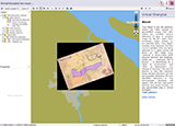
Shanghai Historical Maps |
|
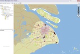
Shanghai XXIth Maps |
...
- 最新更新 週五 15 八月 2025 (16:32) / C. Henriot -
Site created by Gérald Foliot with webActors - Hosted by TGIR Huma-num
The site is part of the Virtual Cities Project: Beijing - Hankou - Saigon - Shanghai - Suzhou - Tianjin - Zhejiang
Select language : English | 简体字 | 繁體字
![]()
![]()
頁面正在處理中 0.004s